江苏科技信息 ›› 2019, Vol. 36 ›› Issue (3): 28-31.doi: 10.1004-7530/2019-36-3-28
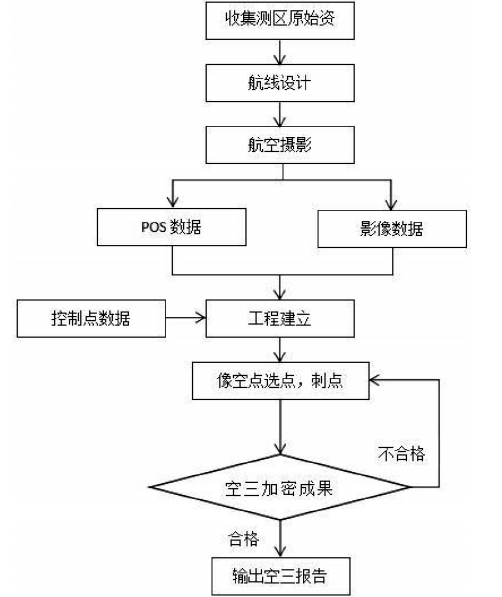
• 基础研究 • 上一篇    下一篇

固定翼无人机在城市大比例尺测图空三试验

李静   

  1. 河南理工大学,河南 焦作 45400
  • 出版日期:2019-01-30 发布日期:2019-07-09
  • 作者简介:李静(1989— ),男,吉林松原人,硕士;研究方向:精密工程测量。

Aerial triangulation experiments based on urban large-scale mapping with fixed wing UAV

Jing Li   

  1. Henan University of Science and Technology, Jiaozuo 454000, China
  • Online:2019-01-30 Published:2019-07-09

摘要:

文章针对固定翼无人机在城市大比例尺测图中的精度问题,利用固定翼无人机在焦作市进行航摄试验。利用Map Matrix软件系统进行空三加密并且对测区内的像控点以及检查点的进行精度分析。结果表明,利用固定翼无人机在城市进行大比例尺测图其精度能够满足1∶500的测图要求。

关键词: 固定翼无人机, 城市大比例尺测图, 空三加密, 精度评定

Abstract:

In this paper, aiming at the accuracy problem of fixed-wing UAV in large-scale urban mapping, fixed-wing UAV is used for aerial photography test in Jiaozuo city. Taking aerial triangulation with MapMatrix software and accuracy analysis of image control points and checkpoints. The results show that the precision of the fixed-wing UAV is able to satisfy the requirement of 1:500 mapping.

Key words: fixed wing UAV, urban large-scale mapping, aerial triangulation, accuracy assessment

中图分类号: